Description
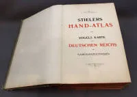
Stielers Hand-Atlas: 100 maps in copper engraving with 162 supplementary maps, fifth corrected impression of Stielers Hand-Atlas and Vogels Karte des Deutschen Reiches, publisher: Gotha, Justus Perthes Geographische Anstalt, publication date 1909, with name indexes, original condition with signs of wear. Dimensions in cm: H 40.5 W 26.5
Stielers Hand-Atlas: 100 Karten in Kupferstich mit 162 Nebenkarten, fünfter berichtigter Abdruck Stielers Hand-Atlas und Vogels Karte des Deutschen Reiches, Verlag: Gotha, Justus Perthes Geographische Anstalt Erscheinungsdatum 1909 mit Namenverzeichnissen, originaler Zustand mit Gebrauchsspuren Maße in cm: H: 40,5 B: 26,5
Machine translation. The seller's German text is authoritative.
Sale conditions
About the sale
Stielers Hand-Atlas and Vogels Karte des Deutschen Reiches, 1909
Original titleStielers Hand - Atlas und Vogels Karte des Deutschen Reiches, 1909
Offered by

Similar lots
 No bids
 No bids
 No bids
 No bids