Description
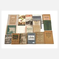
13 pieces, first half of the 20th century, guides to Vogtland, Saxon-Bohemian Switzerland, surroundings of the Franconian Crown and the Saale valley, plus 9 folding hiking maps, including garrison surroundings map Plauen, Greiz, Klingenthal, Bad Kissingen, etc., format max. 8vo, normal, occasionally more pronounced signs of use and age.
13 Stück, 1. Hälfte 20. Jh., Führer durch Vogtland, Die sächsisch-böhmische Schweiz, Umkreis fränkische Krone und Das Saaletal, dazu 9 Wanderfaltkarten, dabei Garnisons-Umgebungskarte Plauen, Greiz, Klingenthal, Bad Kissingen usw., Format max. 8°, normale, vereinzelt deutlichere Gebrauchs- und Altersspuren.
Machine translation. The seller's German text is authoritative.
Sale conditions
About the sale
Bundle of hiking books and maps Vogtland
Original titleKonvolut Wanderbücher und Karten Vogtland
Final result not confirmed: the hammer price may be higher. The auction house's website is authoritative.

Similar lots still for sale
 No bids
 No bids
 No bids
 No bids
 No bids
 No bids