Description
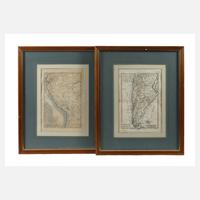
Depiction of the territory of Chile and Peru, coloured copper engravings, second half of the 18th century, slight condition issues, mounted under passe-partout and framed behind glass, passe-partout opening approx. 36 x 24 cm.
Darstellung des Staatsgebiets von Chile und von Peru, kolorierte Kupferstiche, 2. Hälfte 18. Jh., leichte Erhaltungsmängel, unter Passepartout und hinter Glas gerahmt, Passepartoutausschnitt ca. 36 x 24 cm. Info: französischer Mathematiker und Kartograph (1727 Raucourt/Ardennen bis 1794 Paris), 1762 erschien sein erster Atlas maritime, ab 1773 Nachfolger von Jaques-Nicolas Bellins, ab 1776 oberster Ingenieur-Hydrograph der französischen Marine, Entwickler der nach ihm benannten Bonneschen Projektion, Quelle: Wikipedia.
Machine translation. The seller's German text is authoritative.
Sale conditions
About the sale
Rigobert Bonne, pair of maps of South America
Original titleRigobert Bonne, Paar Landkarten Südamerika
Final result not confirmed: the hammer price may be higher. The auction house's website is authoritative.

Similar lots still for sale
 1 bid
 No bids
 1 bid
 No bids
 No bids
 No bids
 No bids
 No bids