Description
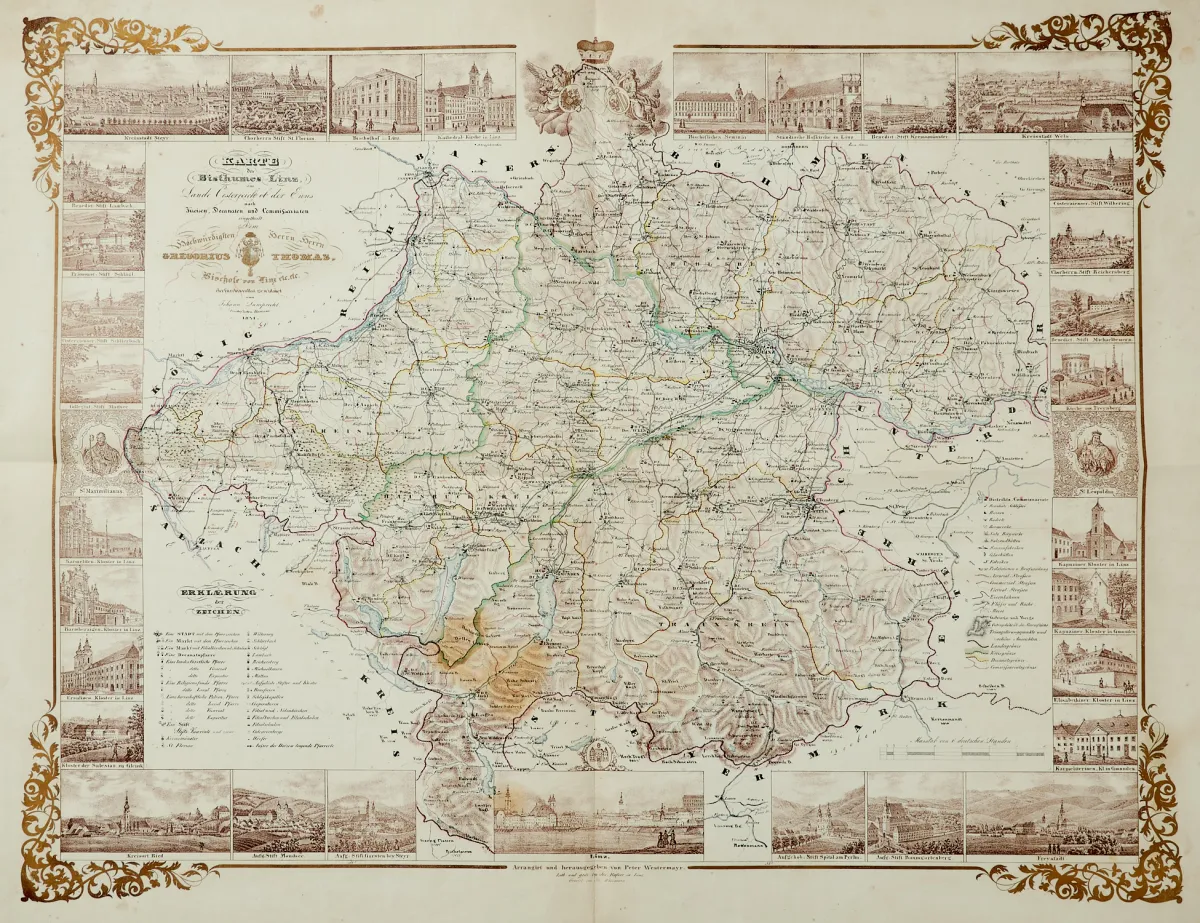
Lithographed map in old outline colouring, divided into circles, deaneries and commissariats, surrounded by 29 small lithographed views and 2 depictions of saints, partly floral border printed in gold, by J. Waizmann and J. Hafner after J. Lamprecht, arranged and published by Peter Westermayr, at J. Hafner in Linz, dated 1841. Approx. 55.5 x 72.5 cm (sheet approx. 64.5 x 81.5 cm). Folded twice.
der Enns, nach Kreisen, Decanaten und Commissariaten eingetheilt". Alt grenzkolor. und zweifarbig lithografierte Karte umgeben von 29 kleinen lithogr. Ansichten und 2 Heiligendarstellungen, in Gold gedruckter tls. floraler Umrahmung, von J. Waizmann und J. Hafner nach J. Lamprecht, "arrangirt und herausgegeben von Peter Westermayr", bei J. Hafner in Linz, dat. 1841. Ca. 55,5 x 72,5 cm (Blattgr.: ca. 64,5 x 81,5 cm). - - Doppelt gefaltet. (32) Giordani 147, 4 und S. 53. ÖBL IV, 421. - Sehr dekorative Bistumskarte umgeben von kleinen Ansichten, darunter die Hauptorte Linz, Steyr, Wels, Ried und Freistadt in den Ecken und unten mittig sowie u.a. Lambach, Schlägl, Schlierbach, Mondsee, Garsten, Spital am Pyrhn, Reichersberg, Wilhering, Michaelbeuern und Kremsmünster.
Machine translation. The seller's German text is authoritative.
Sale conditions
About the sale
Austria - Upper Austria - Map of the Diocese of Linz in the country of Austria above the Enns
Original titleÖsterreich - Oberösterreich - "Karte des Bisthumes Linz im Lande Oesterreich ob
Offered by

Similar lots
 No bids
 No bids
 4 bids
 2 bids