Descrizione
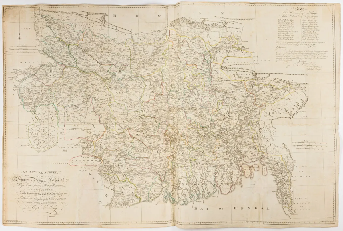
An Actual Survey, of the Provinces of Bengal, Bahar &c. Carta incisa in rame, colorata a mano ai confini, di W. Haydon e Andrew Dury da James Rennell. Londra, Dury, 1776. Dimensioni foglio: 100 x 149 cm. Stampata da 4 lastre e assemblata. Tooley 2 d. 4 S. 33f. - LGK II, S. 663 - Gole 87/1.1 - Carta di grande formato e dettagliata che mostra Bihar, Bengala Occidentale, Jharkhand, Bangladesh, il delta del Gange e parti della Birmania. L'area a sud dell'Himalaya è delimitata
An Actual Survey, of the Provinces of Bengal, Bahar &c. Grenzkolorierte Kupferstich-Karte von W. Haydon und Andrew Dury nach James Rennell. London, Dury, 1776. Blattmaße: 100 x 149 cm. Von 4 Platten gedruckt und zusammengesetzt. Tooley 2 d. 4 S. 33f. - LGK II, S. 663 - Gole 87/1.1 - Großformatige und detaillierte Karte, die Bihar, Westbengalen, Jharkand, Bangla Desh, Ganges-Delta und Teile Birmas zeigt. Das Gebiet südlich des Himalaya wird begrenzt durch Bettiah, Rangamatty, Cospour, die Küste von Arakan, Balasur, Varanasi (Benares) und Ghazipur. Oben rechts große Widmung an die Direktoren der East India Company, mit Auflistung ihrer Namen. Im Verlag von Andrew Dury erschien 1776 die nach Vorlagen von James Rennell geschaffene Karte. Rennell (1742-1830) war Kartograph, Geograph und als Topograph für die East India Company tätig. Nachdem Großbritannien das Gebiet Bengalen erworben hatte, wurde 1767 das Amt eines "Surveyor General" geschaffen und Rennell damit betraut. 1777 kehrte er nach England zurück, um dort seine geographischen Forschungen fortzusetzen. - Mittelfalten, mit Faltspuren. - Kurze Einrisse im schmalen Papierrand restauriert, kleine Fehlstelle (7 x 4 cm) im Bereich des Golfes von Bengalen hinterlegt, unten links in einem kartographisch nicht ausgeführten Teil der Provinz Orixa Papierausriss ca. 19,5 x 9,5 cm ergänzt, kleine Eckabrisse oben links in der Randleiste ergänzt, leicht gebräunt und fleckig.
Traduzione automatica. Fa fede il testo tedesco della casa d'aste.
Condizioni di vendita
Secondo le condizioni di vendita: « Aufbewahrung und Versand erfolgen auf Rechnung der Käufer; die Kosten für Versand, Verpackung und Versicherung werden mit der Gesamtrechnung berechnet. »
Informazioni sulla vendita
Asia – India – An Actual Survey, of the Provinces of Bengal, Bahar &c. Carta incisa in rame, colorata a mano ai confini
Titolo originaleAsien - Indien – An Actual Survey, of the Provinces of Bengal, Bahar &c. Grenzkolorierte Kupferstich-Karte von W. Haydon und Andrew Dury…

Lotti simili
 Senza offerte
 3 offerte
 Senza offerte
 Senza offerte