Description
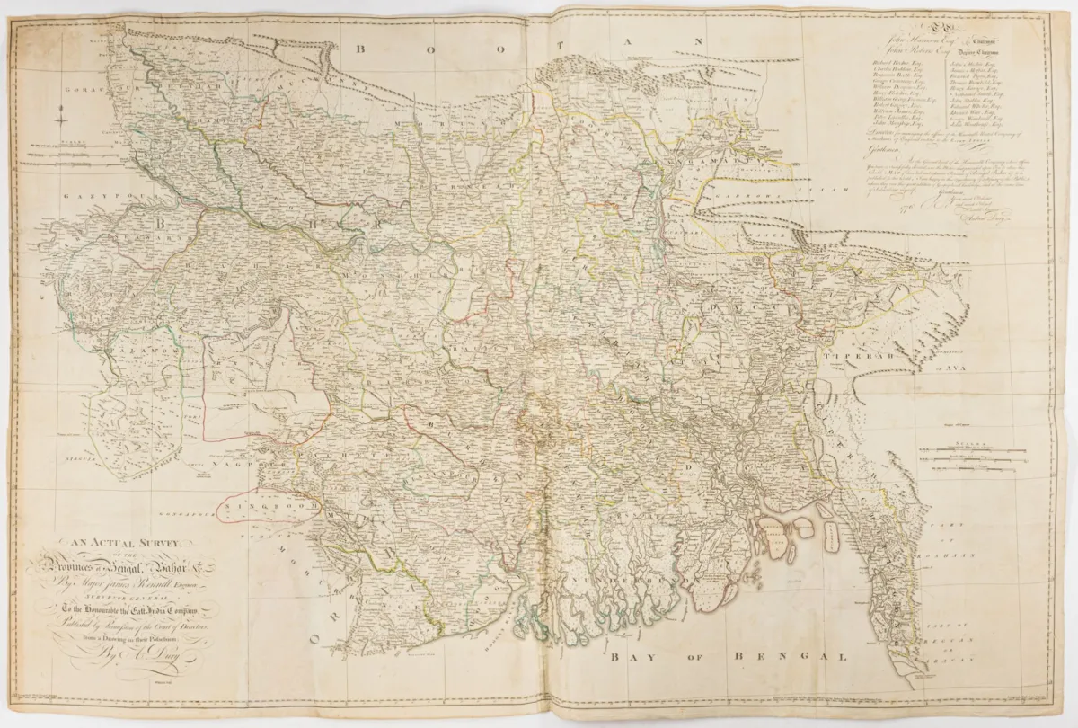
An Actual Survey, of the Provinces of Bengal, Bahar &c. Hand-coloured engraved map by W. Haydon and Andrew Dury after James Rennell. London, Dury, 1776. Sheet dimensions: 100 x 149 cm. Printed from 4 plates and assembled. Tooley 2 d. 4 p. 33f. - LGK II, p. 663 - Gole 87/1.1 - Large-format and detailed map showing Bihar, West Bengal, Jharkhand, Bangladesh, the Ganges Delta and parts of Burma. The area south of the Himalayas is delimited...
An Actual Survey, of the Provinces of Bengal, Bahar &c. Grenzkolorierte Kupferstich-Karte von W. Haydon und Andrew Dury nach James Rennell. London, Dury, 1776. Blattmaße: 100 x 149 cm. Von 4 Platten gedruckt und zusammengesetzt. Tooley 2 d. 4 S. 33f. - LGK II, S. 663 - Gole 87/1.1 - Großformatige und detaillierte Karte, die Bihar, Westbengalen, Jharkand, Bangla Desh, Ganges-Delta und Teile Birmas zeigt. Das Gebiet südlich des Himalaya wird begrenzt durch Bettiah, Rangamatty, Cospour, die Küste von Arakan, Balasur, Varanasi (Benares) und Ghazipur. Oben rechts große Widmung an die Direktoren der East India Company, mit Auflistung ihrer Namen. Im Verlag von Andrew Dury erschien 1776 die nach Vorlagen von James Rennell geschaffene Karte. Rennell (1742-1830) war Kartograph, Geograph und als Topograph für die East India Company tätig. Nachdem Großbritannien das Gebiet Bengalen erworben hatte, wurde 1767 das Amt eines "Surveyor General" geschaffen und Rennell damit betraut. 1777 kehrte er nach England zurück, um dort seine geographischen Forschungen fortzusetzen. - Mittelfalten, mit Faltspuren. - Kurze Einrisse im schmalen Papierrand restauriert, kleine Fehlstelle (7 x 4 cm) im Bereich des Golfes von Bengalen hinterlegt, unten links in einem kartographisch nicht ausgeführten Teil der Provinz Orixa Papierausriss ca. 19,5 x 9,5 cm ergänzt, kleine Eckabrisse oben links in der Randleiste ergänzt, leicht gebräunt und fleckig.
Machine translation. The seller's German text is authoritative.
Sale conditions
According to the sale terms: « Aufbewahrung und Versand erfolgen auf Rechnung der Käufer; die Kosten für Versand, Verpackung und Versicherung werden mit der Gesamtrechnung berechnet. »
About the sale
Asia - India – An Actual Survey, of the Provinces of Bengal, Bahar &c. Hand-coloured engraved map by W. Haydon and Andrew Dury
Original titleAsien - Indien – An Actual Survey, of the Provinces of Bengal, Bahar &c. Grenzkolorierte Kupferstich-Karte von W. Haydon und Andrew Dury…

Similar lots
 No bids
 No bids
 3 bids
 No bids